Water records, wetland maps, wildlife observations and the standards that guide a County decision. Save Homestake opposes Whitney Reservoir. This record shows what supports that position and which decisions still need a documented answer.
Read measured data, calculations, modeled exposure and regional science in their own terms. Source IDs stay with the claims across the website and document family.
Read the evidence family
Executive Evidence Brief
A short visual introduction to the evidence and decision questions.
During WY2007–2024, recorded Homestake Tunnel export totaled 420,676.93 AF and flow passing Gold Park totaled 386,968.01 AF. Across these two recorded routes, 52.09% was exported through the tunnel and 47.91% passed Gold Park.
Geography
Gold Park gauged catchment, USGS 09064000; official drainage area 35.6 square miles
Period
WY2007–2024
Calculation
420,676.93 ÷ (420,676.93 + 386,968.01) × 100 = 52.09% tunnel export. The remainder is 47.91% passing Gold Park.
Scope
The denominator is the sum of two recorded routes, not a verified estimate of all natural Homestake runoff. Lower Homestake tributaries below Gold Park are outside this gauge comparison.
Why it matters
The recorded export is large relative to the creek flow continuing through the upstream gauge. Seasonal operations and the remaining balance terms determine how that scale translates into local water availability.
Recorded Homestake Tunnel export averaged 23,370.94 AF/year during WY2007–2024; flow passing Gold Park averaged 21,498.22 AF/year over the same 18 water years.
Geography
Gold Park gauged catchment / whole Homestake Tunnel export
Period
WY2007–2024
Calculation
Tunnel: 420,676.9294 AF ÷ 18 years = 23,370.94 AF/year. Gold Park: 386,968.0066 AF ÷ 18 = 21,498.22 AF/year.
Scope
WY is October 1 through September 30. Export and gauge flow are observed accounting paths after existing project operation.
Adding endpoint storage change and recorded evaporation accounts to the two-route denominator gives a partial-balance export comparison of 51.75% for WY2007–2024.
Geography
Gold Park gauged catchment / existing project accounting
This partial balance is not completed naturalization or an uncertainty interval. External inflow, project-induced net losses, reservoir precipitation, evaporation relative to the no-project landscape, and measurement corrections remain unresolved. Do not substitute the separate net-flow-reduction formula, which changes the numerator.
During WY2007–2011, recorded Homestake Tunnel export was 139,942.66 AF and recorded flow at Red Cliff was 185,166.87 AF. Export was 43.04% of their combined recorded total.
Geography
USGS 09064500 Red Cliff gauge catchment (58.2 square miles), a larger and downstream drainage than Gold Park
Preserves the original DWR-published USGS annual total; current USGS daily aggregation differs by 19.87 AF over five years. Gold Park and Red Cliff differ in drainage area, period and downstream contributions. They are separate comparisons, not an uncertainty range. Red Cliff town, gauge and the full Homestake mouth are distinct locations.
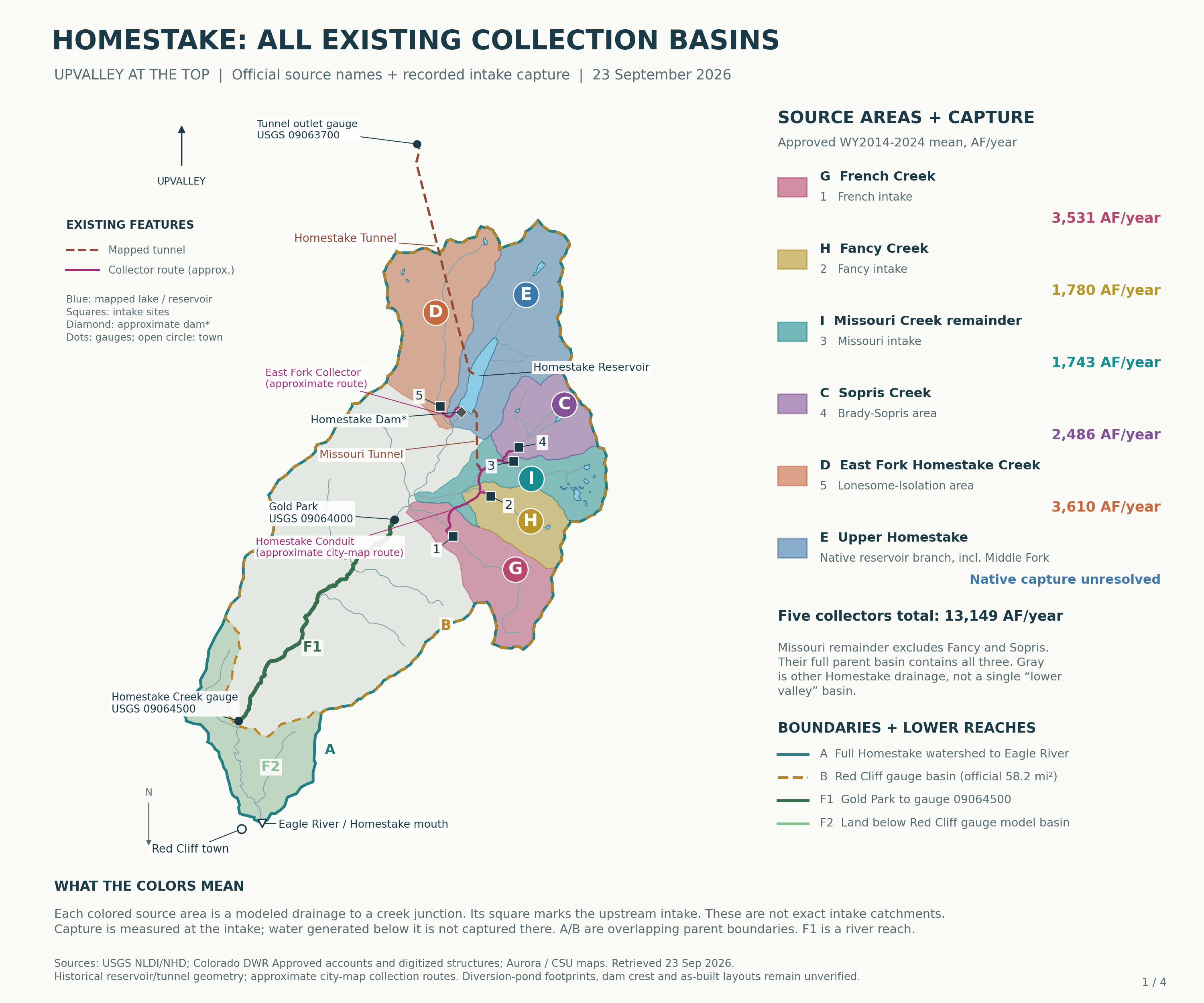
Five existing tributary intake records total 144,638.46 AF for WY2014–2024, averaging 13,148.95 AF/year. Annual averages are French 3,530.90, Fancy 1,779.67, Missouri 1,742.73, Sopris 2,485.52 and East Fork 3,610.13 AF/year.
Geography
Existing French, Fancy, Missouri, Sopris and East Fork intakes
Period
WY2014–2024
Calculation
144,638.4649 AF ÷ 11 water years = 13,148.95 AF/year combined. French 3,530.90; Fancy 1,779.67; Missouri 1,742.73; Sopris 2,485.52; East Fork 3,610.13 AF/year.
Scope
Collector records overlap subsequent reservoir and tunnel accounts. Never add collector capture to whole-tunnel exports as separate withdrawals. French and Sopris WY2016 capture accounts are Approved all-zero records; raw records are preserved and their physical interpretation remains an agency question.
All five existing Homestake tributary intake sites and Homestake Reservoir fall upstream of Gold Park in the retrieved USGS basin delineation. The station’s published drainage area is 35.6 square miles.
Geography
Gold Park upstream catchment
Period
September 23, 2026 spatial source check
Scope
The NLDI polygon snaps to a flowline unit; use the station’s official drainage area rather than polygon area. Gold Park flow combines bypass, releases and water never intercepted. It is neither natural runoff nor an individual tributary measurement.
The reviewed evidence identifies Whitney storage concepts of 6,850–20,000 AF and a broader Eagle River Joint Use objective of up to 20,000 AF/year. Whitney-only dependable annual yield remains an unresolved records question.
Geography
Whitney concepts / broader Eagle River Joint Use Project
Period
Reviewed record through September 23, 2026
Scope
Storage is a volume in AF; annual yield is a rate in AF/year. Compare demand savings against annual yield on a common time basis.
Why it matters
Necessity, feasibility and alternatives turn on the reliable supply actually delivered.
Known
Storage concepts and broader project annual objective are in the reviewed record.
Needed record
Whitney-only dependable/dry-year yield, source-specific collections, initial fill/refill, evaporation, bypasses, operating levels and final works.
Record holder
Homestake partners and design/operations consultants
Decision relevance
Necessity, feasibility and alternatives turn on the reliable supply actually delivered.
The September 23, 2026 Homestake Valley BioBlitz snapshot contains 1,400 observations, 229 terminal taxon concepts and 190 species-rank concepts: 618 Research Grade, 778 Needs ID and four Casual records.
Geography
Homestake Valley BioBlitz project membership
Period
Snapshot September 23, 2026
Scope
Observation and taxon concepts are separate counts. Identification grades remain visible; this is an opportunistic project record.
GBIF Homestake/Colorado discovery returned 379 records; 242 passed Eagle County plus locality-name screen; nine school records excluded; 233 retained: 129 eBird-derived, 103 specimens and one other occurrence.
Geography
Eagle County records screened for Homestake locality
Period
Dated occurrences retained in September 23, 2026 snapshot
Scope
Records, not distinct species, animals or checklists; historic/locality/taxonomic uncertainty retained.
CNHP’s 2000 Eagle County survey documents boreal-toad breeding in upper Homestake tributaries. Historical monitoring also records pond drying and recruitment questions.
Geography
Upper Homestake tributaries / Holy Cross City PCA
Period
CNHP 2000 survey and 2006–2007 historical monitoring
Scope
Historical breeding record. Current occupancy, breeding success and recruitment are questions for a new survey.
Why it matters
Breeding habitat and its seasonal water supply have a documented place in the valley’s conservation case.
In Rocky Mountain National Park and nearby areas, 90% of the sampled summer locations were within about 285 metres of mapped water. The mean distance was about 110 metres.
Geography
Rocky Mountain National Park and vicinity, Colorado
Period
GPS data from 21 adults; 1,672 locations; 12-hour fixes, June–August 2017–2018
Method
21 adult moose; 1,672 GPS locations; June to August 2017 and 2018. Distance was measured to mapped flowing or standing water. The study used those observations to design an aerial survey.
Scope
Regional ecological evidence. 21 adult moose; 1,672 GPS locations; June to August 2017 and 2018. Distance was measured to mapped flowing or standing water. The study used those observations to design an aerial survey.
Why it matters
Water, willow forage and nearby forest belong together in the habitat assessment.
Across 37 Colorado stream reaches, researchers found smaller channel dimensions below diversions and vegetation shifting toward drier-site species.
Geography
North-central Colorado Rocky Mountains
Period
37 low-gradient reaches: 16 upstream/downstream pairs plus five unpaired reaches; 100 vegetation points per reach
Method
North-central Colorado; 16 paired reaches and five unpaired reaches, with 100 vegetation sampling points per reach. Comparative field study.
Scope
Regional ecological evidence. North-central Colorado; 16 paired reaches and five unpaired reaches, with 100 vegetation sampling points per reach. Comparative field study.
Why it matters
A diversion review needs stream cross-sections, seasonal flows and plant transects through the connected floodplain.
Monitoring in Rocky Mountain National Park found that two beaver dams slowed seasonal groundwater decline across areas of 9 and 12 hectares, respectively.
Geography
Rocky Mountain National Park, Colorado
Period
Two beaver dams along 1.5 km of stream; 58-ha study area; monitoring 2002–2005
Method
Two dams along 1.5 kilometres of stream in one 58-hectare valley, monitored during 2002 to 2005. The measured areas describe those dams and should not be added or applied as buffers elsewhere.
Scope
Regional ecological evidence. Two dams along 1.5 kilometres of stream in one 58-hectare valley, monitored during 2002 to 2005. The measured areas describe those dams and should not be added or applied as buffers elsewhere.
Why it matters
Protecting a beaver complex includes its groundwater and floodplain connections.
At four previously drained Colorado fens, ditch blocking raised summer water tables. At the site restored 20 years earlier, disturbed surface peat still differed from reference peat.
Geography
Four Colorado mountain fens
Period
Four century-drained sloping fens restored 1–20 years previously; 89 wells at three short-term sites; 2008–2010 water tables and 2009–2010 growing-season CO2 flux
Method
Four Colorado mountain fens restored 1 to 20 years before study. This research examined restoration of existing drained peat.
Scope
Regional ecological evidence. Four Colorado mountain fens restored 1 to 20 years before study. This research examined restoration of existing drained peat.
Why it matters
Mitigation must account for peat structure and the duration of lost function, alongside water levels and vegetation.
In northern California's upper Shasta River, drifting invertebrate prey approached zero below a diversion late in the season even though benthic biomass could be higher there.
Geography
Upper Shasta River, northern California
Period
One diversion in wet 2019; 13 sampling events Dec 2018–Dec 2019; 18 benthic and six drift sites; fish diets from one pool above and one below
Method
Regional comparison outside Colorado: one diversion during wet 2019, with 13 sampling events and limited fish-pool replication. The local measurement requested is prey delivery through the low-flow season.
Scope
Regional ecological evidence. Regional comparison outside Colorado: one diversion during wet 2019, with 13 sampling events and limited fish-pool replication. The local measurement requested is prey delivery through the low-flow season.
Why it matters
Homestake's aquatic assessment should measure food moving with the water as well as insects living on the streambed.
Canada lynx in the contiguous United States are federally Threatened; Colorado classifies the species as State Endangered. The July 16, 2026 final critical-habitat rule took effect August 17, 2026. Unit 6 includes portions of Eagle County.
Geography
Contiguous-US DPS; Colorado; Unit 6 includes portions of Eagle County
Period
Current status checked September 23, 2026
Scope
The final designation map must be intersected with a selected project footprint to determine its boundary relationship.
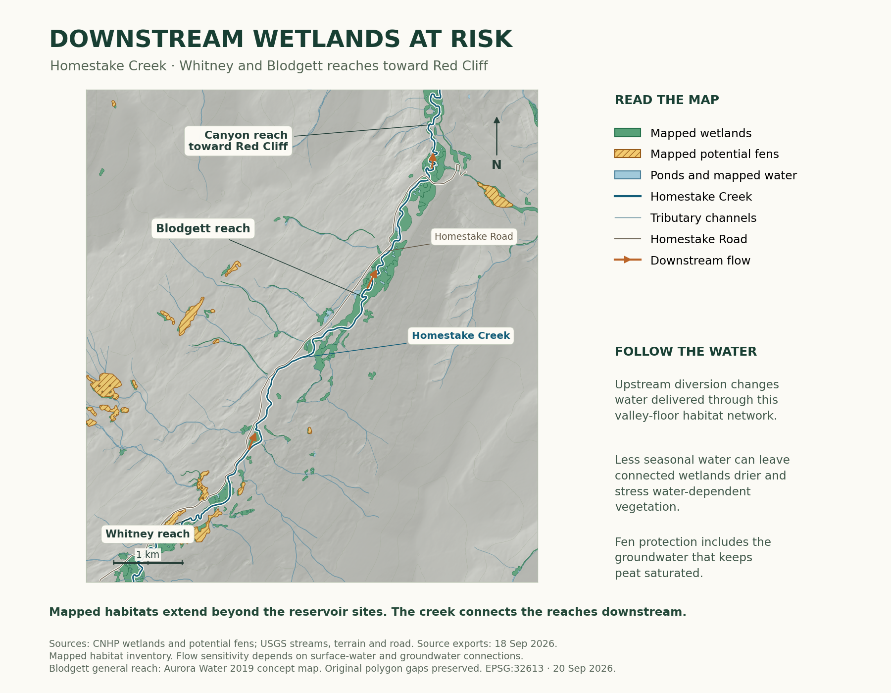
The same downstream query envelope returned 18 Potential Fen features from the older CNHP service and six from Fens 2025. Five newer polygons overlap older polygons, one does not, and no pair has equal geometry.
Geography
Existing downstream map WGS84 envelope
Period
September 23, 2026 GIS comparison
Scope
Counts are returned service features, not a number of destroyed or disappeared fens. Geometry comparison is complete; authoritative version correspondence, classification and source currency await CNHP. Retain September 18 map inventory; no reservoir exposure or acreage update follows from the feature-count difference.
Aurora's IWMP 2 already includes continued conservation in all demand scenarios, including reducing existing residential indoor use from 47 to 40 gpcd and reducing existing turf.
Geography
Aurora
Period
January 2025 IWMP2, Revision 1
Scope
Do not subtract these baseline assumptions again when calculating incremental alternatives
Aurora reports water-use reductions, Prairie Waters reuse and new-development turf restrictions. Colorado Springs Utilities reports a 40% per-capita consumption decline since 2001 and 276 AF/year of savings gained through its 2024 conservation programs. Planned conservation already included in forecasts must be separated from additional savings.
Geography
Aurora and Colorado Springs municipal systems
Period
Reviewed September 23, 2026
Why it matters
A fair alternatives comparison credits completed progress and tests further practical savings using the same time period and reliability assumptions.
Fens are groundwater-supported peat-forming wetlands. Colorado restoration research found that raising water tables did not erase all differences in disturbed surface peat even at a site restored 20 years earlier. Peat structure, hydrology and the duration of lost function belong in any mitigation assessment.
Geography
General fen definition; four Colorado mountain fen restoration sites
Period
Reviewed September 23, 2026
Method
Four restored Colorado mountain fens, restored 1–20 years before study; regional ecological evidence.
Why it matters
Protecting the fen means retaining the conditions that build and sustain peat, as well as its mapped area.
The inspected County record retains current Chapter VI as the governing code. The latest posted replacement is the September 15, 2026 draft. The September 23 resolution attachments are unsigned templates. A recommendation outcome has not been verified. The County lists an October 27 adoption hearing, 2:30–4 p.m.; staff recommends simultaneous effectiveness with the readopted land-use regulations.
Geography
Eagle County
Period
Reviewed September 23, 2026
Why it matters
Approval questions must use the enacted, effective text and the applicable transition rules.
Known
Current code, posted draft, hearing schedule and staff transition recommendation.
Needed record
Completed vote, signed resolution, adopted text, effective date and transition provisions.
Record holder
Eagle County Community Development and Clerk to the Board.
Decision relevance
Determines the applicable approval standards and when any new text governs.
Published adopted Chapter VI, independently checked September 23, 2026. Archived EnCode export: decision §6.03.10, PDF pp.16-17; criteria §§6.04.01-.02, PDF pp.19-20; Appendix A, PDF pp.24-29. County-linked legacy layout contains equivalent criteria with different pagination. Original pertinent pages attached.
Latest proposed text located on the official application record as of September 23, 2026: September 15, 2026 draft. Printed page numbers are four less than PDF numbers. Proposed §§109, 211, 301-331 and 401-434. No adoption/effective date verified. Original pertinent pages attached.
Official LUR-009633-2026 record checked September 23, 2026. Recommendation hearing scheduled September 23; no completed recommendation/vote verified. Board adoption hearing scheduled October 27, 2:30-4 p.m. Posted recommendation resolutions have blank votes/signatures.
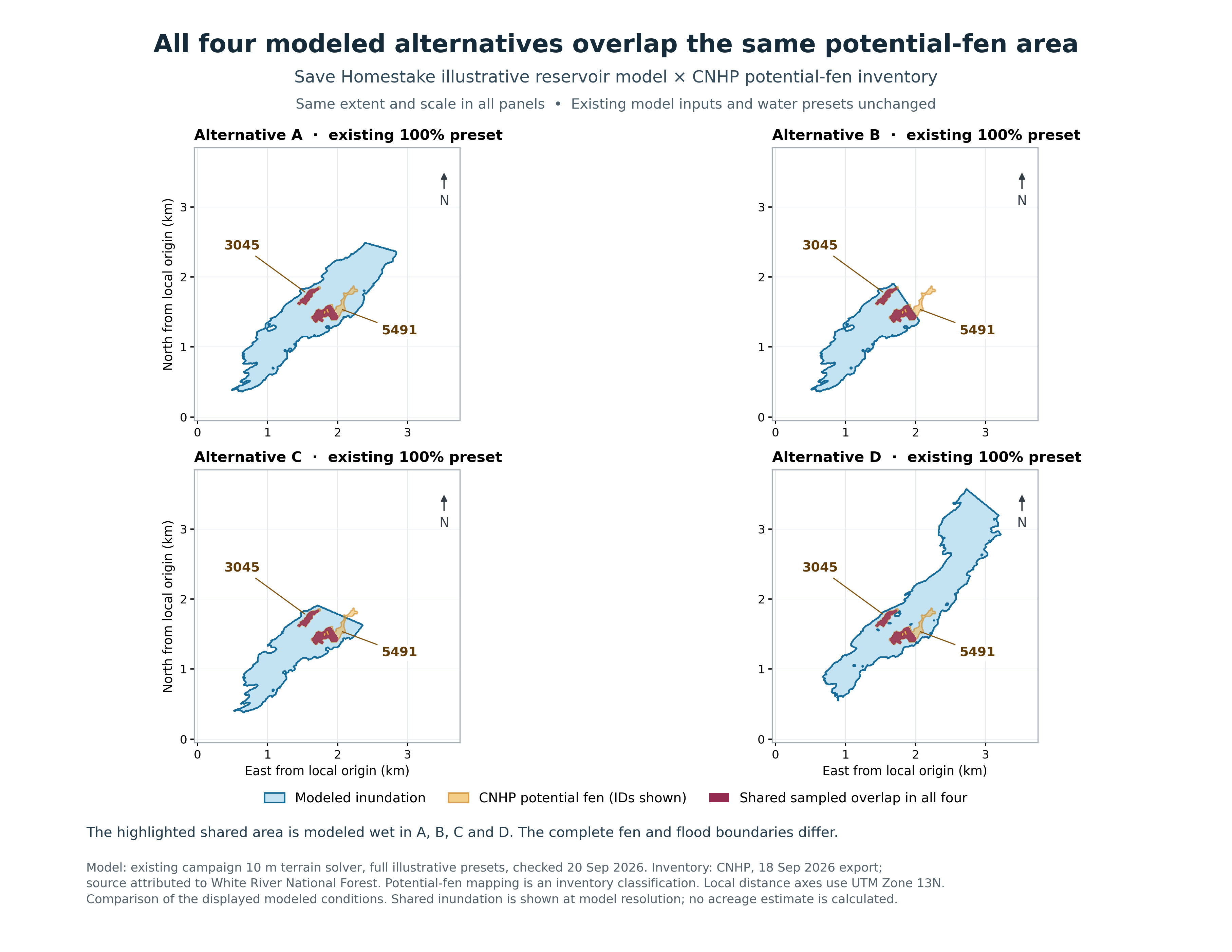
Save Homestake’s modeled full-pool A–D alternatives each intersect the mapped fen complex. The maps compare campaign-modeled water surfaces with the retained habitat inventory. They are screening exhibits for review of inundation and complete-project exposure.
Geography
Homestake Valley
Period
Reviewed September 23, 2026
Why it matters
The permanent and temporary project footprint needs to account for dam, reservoir, roads, power, pumping, tunnels, spoil and maintenance together.
Campaign interpretation of the mapped fen complex and modeled reservoir alternatives. Model-based conclusions concern the displayed alternatives and water elevations.
Based on the compiled evidence and identified approval standards, Save Homestake’s position is that the record supports denial of Whitney Reservoir if the applicable standards cannot be demonstrated or ensured through enforceable conditions.
At the unchanged 100% illustrative presets, Save Homestake’s four modeled inundation areas share 81.40005 acres of overlap with the dissolved mapped-wetland and Potential Fen inventory, excluding mapped-water categories.
Geography
Shared intersection of campaign-modeled A–D inundation areas and September 18 CNHP inventory
Period
September 20 model; reproduced September 23, 2026
Calculation
{'shared_overlap_acres': 81.40004948899694, 'method': 'Union model water-surface triangles; intersect with dissolved wetland and Potential Fen geometry in EPSG:32613; exclude mapped-water categories.'}
Scope
This is the campaign model and dated inventory, not an official applicant footprint or field-delineated jurisdictional acreage. This acreage is not a percentage of Aurora’s parcel. No final construction footprint is supplied by the model; dam-toe arrows on maps are schematic.
Documentation that prior to site disturbance for the Project the applicant will have obtained all necessary property rights, permits and approvals. The Board may, at its discretion, defer making a final decision on the application until outstanding property rights, permits and approvals are obtained.
Geography
Eagle County
Period
Current Chapter VI checked September 23, 2026
Scope
Exact current-code text. Draft comparison is separate: 404. September 15 2026 proposal; adoption/effectiveness not verified
Why it matters
Retains pre-disturbance requirement; Board may defer final decision.
The Project will not have a significant adverse effect on the capability of local governments affected by the Project to provide services, or exceed the capacity of service delivery systems.
Geography
Eagle County
Period
Current Chapter VI checked September 23, 2026
Scope
Exact current-code text. Draft comparison is separate: 419. September 15 2026 proposal; adoption/effectiveness not verified
The benefits accruing to the County and its citizens from the Project outweigh the losses of any natural, agricultural, recreational, grazing, commercial or industrial resources within the County, or the losses of opportunities to develop such resources.
Geography
Eagle County
Period
Current Chapter VI checked September 23, 2026
Scope
Exact current-code text. Draft comparison is separate: . September 15 2026 proposal; adoption/effectiveness not verified
Why it matters
No equivalent stand-alone Article 4 criterion. Do not carry this current balancing test into draft as though retained.
Urban development, population densities, and site layout and design of storm water and sanitation systems shall be accomplished in a manner that will prevent the pollution of aquifer recharge areas.
Geography
Eagle County
Period
Current Chapter VI checked September 23, 2026
Scope
Exact current-code text. Draft comparison is separate: 407. September 15 2026 proposal; adoption/effectiveness not verified
Why it matters
Related standard on development/population-associated recharge pollution.