Community science field guide

Learn the valley. Record its life. Visit responsibly.

The complete BioBlitz record, public-road directions, interactive habitat map, safety guidance, and field kit now live in one place.

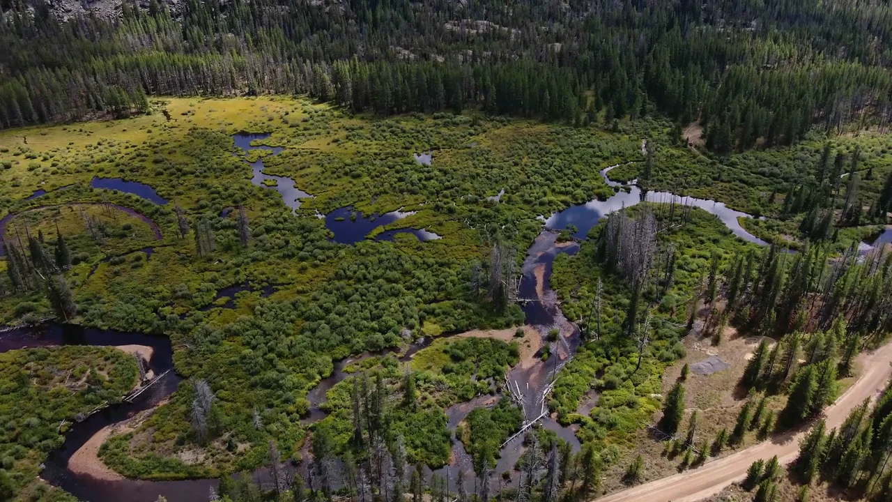
Homestake Valley wetland mosaic. Campaign aerial footage.

01 / Community science

Eagle River Coalition + Wilderness Workshop

Explore the Homestake Valley BioBlitz.

Eagle River Coalition and Wilderness Workshop lead this community science campaign to document the plants, animals, insects, fungi, and wetlands that make Homestake Valley alive.

Look how much life this valley holds.

Wilderness Workshop launched the project in August 2022 with partners including Eagle River Watershed Council, now Eagle River Coalition. Volunteers and specialists have kept the public record growing ever since.

Aerial view of fen wetlands, beaver ponds, and creek channels in Homestake Valley
Existing conditionsFens, beaver ponds, the creek, and forest all meet here.

Campaign aerial footage of Homestake Valley.

Project snapshot
1,400field observationsEach is a dated record of life found in the valley.
229kinds of life identifiediNaturalist calls these taxa: groups such as species or genera.
102people contributingUnique observer accounts represented in this snapshot.
618Research Grade recordsResearch Grade means iNaturalist's evidence and community identification standards are met.

Snapshot of the ongoing iNaturalist project, including Homestake Valley observations made before the first organized BioBlitz in 2022.

What a BioBlitz is

People working together to find and record as much life as possible.

Volunteers and specialists photograph plants, animals, insects, fungi, and other life, then add those observations to a shared iNaturalist record. Homestake's project began in August 2022 and now spans years of field documentation.

When it happens

One community field day every summer. Citizen science all year.

The annual field day is generally held in June or July. The iNaturalist project never closes, so anyone can contribute whenever they visit the valley.

Become a citizen scientist

No expertise required.

Photograph what you find, upload it to the Homestake Valley BioBlitz, and let the iNaturalist community help identify it.

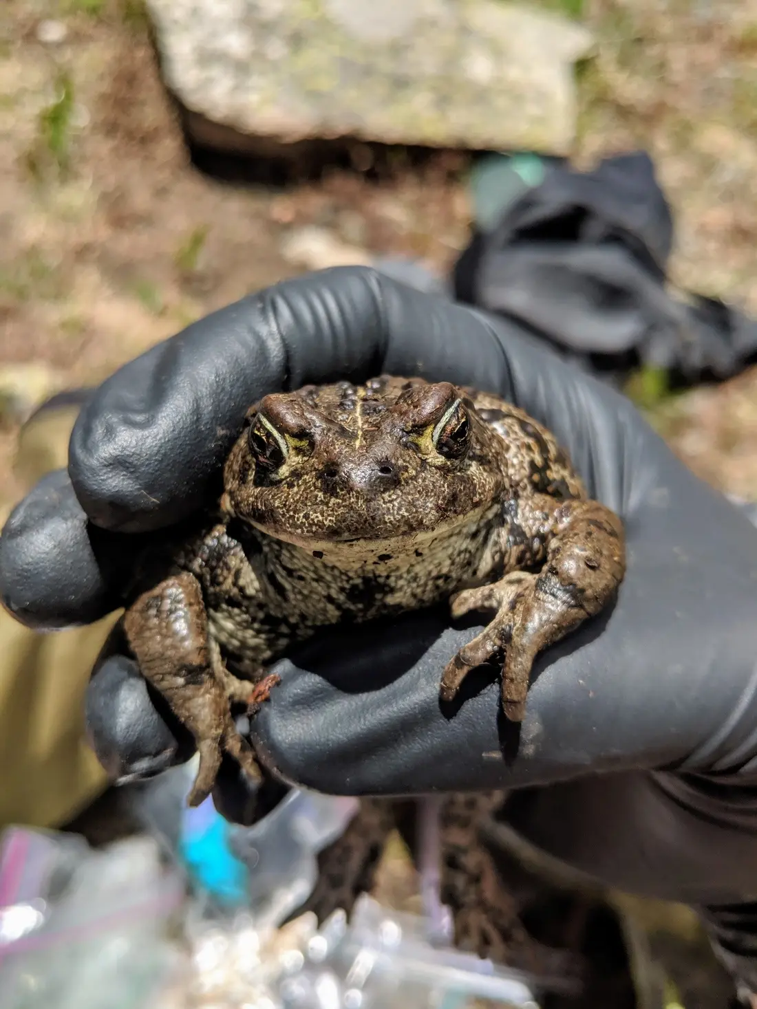
An adult boreal toad resting in a gloved hand
Boreal toadAnaxyrus boreas boreasPhoto: Dana Shellhorn / U.S. Fish and Wildlife Service · Public domain

Denver Zoo Conservation Alliance + Colorado Parks and Wildlife

Join Team Toad.

Colorado's only alpine toad is State Endangered. Team Toad trains volunteer community scientists to search high-elevation wetlands from May through August, record habitat data, and swab encountered amphibians for chytrid fungus. Their findings help Colorado Parks and Wildlife understand wild populations, discover populations not yet documented, and identify places for future recovery work.

Learn in the field

No science degree required.

Start with a staff-led field day covering identification, data collection, safe amphibian handling, and disinfection. Then join more field days or survey with a friend.

May through August

Search when the high country wakes up.

Surveys are most productive soon after a wetland melts out or roughly six to ten weeks later, when tadpoles are easier to see.

Be a better wetland steward

Move clean between habitats.

Chytrid fungus and other aquatic hitchhikers can travel on boots, waders, and wet equipment. A few deliberate habits help keep one wetland from exposing the next.

  1. Brush footwear clean

    Scrub mud, plants, and organic material from boots and waders after every wetland visit.

  2. Disinfect wet gear

    Treat footwear and every piece of gear that entered the water before using it at another site.

  3. Start the next site clean

    Arrive at every new wetland with clean, disinfected, and fully dry gear whenever possible.

Directions + BioBlitz habitat map

Use these three marked destinations along Homestake Road to reach the Whitney and Lone Rock fen areas. Observe and photograph from public roads and public National Forest land.

Use established roads, trailheads, and parking areas. Respect private property and all posted boundaries. Do not cross into City of Aurora-owned land or any other private property. Keep vehicles on open roads and protect the fens by staying on durable ground.

Know before you go

Wetlands, waterways, and ownership

Numbered pins mark the three public-road approaches. Cool-color layers map potential fens, other wetlands, river and stream channels, and ponds across the valley, including inside the City of Aurora property. Rust and coral mark private land.

BioBlitz access map showing wetlands, fens, waterways, public land, and private parcels An aerial map of Homestake Road with mapped potential fens, other wetlands, river and stream channels, ponds, and land ownership continuing across the full zoomed-out extent. The habitat layers continue across the City of Aurora property, smaller private parcels, and public National Forest land. Pins 1–3 mark public-road approach points. Pins 4 and 5 mark wetland areas of interest for BioBlitz. Whitney Creek Trailhead approach1 Lone Rock Fen Area 1 roadside approach2 Lone Rock Fen Area 2 roadside approach3 BioBlitz area of interest 4: Wetlands above Aurora’s property4 BioBlitz area of interest 5: Wetlands above Reservoir D dam5 A B C D

500 m

Tap map to explore full screen

WaterFens / potentialPrivate
Stay on public land.Use Homestake Road, established parking, and public National Forest land. Do not enter the City of Aurora parcel or any other private parcel, even where a mapped wetland or water feature crosses a property line.
Habitat crosses the property line.Mapped wetlands, potential fens, Homestake Creek, Whitney Creek, unnamed tributaries, and ponds all continue through the City of Aurora parcel.

Boundary reference: Eagle County GIS parcels and Colorado land-management mapping. Potential fen shapes: CNHP White River National Forest potential fen mapping. Other wetland, channel, and pond shapes: CNHP Colorado Wetland Inventory / National Wetlands Inventory, mapped from 2011 imagery. Stream lines and names: USGS 3D Hydrography Program. Whitney A–D: modeled full-pool footprints from our valley explorer. Aerial: USDA / USGS 2019 NAIP. Use this map to plan, then follow current posted signs on site.

Field visit checklist

Pack for a self-contained day.

Weather changes quickly at high elevation, and the fen approaches do not have dependable visitor services. Bring what you need to stay warm, fed, hydrated, and prepared to pack out every item you carry in.

Clothing

Wear for mountain weather

Bring waterproof boots with traction, warm non-cotton layers, a rain shell, sun hat, sunglasses, sunscreen, and spare dry socks.

Food + water

Fuel the full outing

For a half day, bring at least 2 liters of water per person, with more for heat or a longer visit. Pack lunch, high-energy snacks, and a little extra food in case the day runs long.

Toiletries + waste

Plan to pack it out

Do not count on restrooms at the fen approaches. Carry hand sanitizer, toilet paper, sealable waste bags, and a WAG bag as a backup. Pack out all toilet paper, wipes, hygiene products, food scraps, and trash.

Safety + field gear

Stay ready and reachable

Carry a charged phone, offline map, power bank, first-aid kit, headlamp, insect repellent, personal medication, notebook, and camera or binoculars. Tell someone your route and return time.

Documented life

Research-grade project records include white bog orchid, queen's crown, American beaver, moose, elk, boreal chorus frog, and olive-sided flycatcher, revealing the valley's extraordinary variety of life.

2022 / Project launch

30+ volunteers

By the time Wilderness Workshop published its launch account, the ongoing project had logged nearly 300 observations and identified 90 species.

Read the 2022 account
2023 / Fen focus

Nearly 50 participants

Teams documented fen plants and small water-dwelling animals, including insects, and added observations to iNaturalist. More than 120 species had been inventoried.

Read the 2023 report
2024 / Third field season

900+ observations

Wilderness Workshop's post-season update reported more than 900 observations documenting more than 187 species in the ongoing project.

Read the 2024 update
2026 / Work continues

29 participants

The July field day logged plants, algae, and small water-dwelling animals including insects, and brought specialists back into the fens for another bilingual community event.

Read the 2026 report

Credit the record

The organizations behind the work.

Organized by: Wilderness Workshop and Eagle River Watershed Council, now Eagle River Coalition.

Credited contributors and participants across field seasons: Rocky Mountain Wild, Walking Mountains Science Center, Colorado Natural Heritage Program, Sierra Club, Audubon Rockies, Roaring Fork Audubon, and WildEarth Guardians.

2026 expertise and event support: Colorado Mountain College and Colorado Wild provided specialists, Walking Mountains provided transportation, and the Xcel Energy Foundation supported the bilingual event.

The project records life observed across Homestake Valley. Explore the observations to see what people have found.

About these observations

The totals are the September 23, 2026 snapshot of the Homestake Valley iNaturalist project: 1,400 observations, 229 terminal taxon concepts, including 190 at species rank. Research Grade, Needs ID and Casual records retain their iNaturalist classifications.

Essential cleaning guidance without JavaScript

Clean first, then choose one proven method. Remove every trace of mud, plants, and organic material. For compatible gear, use 140°F / 60°C water for 10 minutes. As a separate alternative, let gear dry completely for at least 10 days, counting only after seams, felt, and foam are fully dry. Team Toad volunteers should follow the exact trained protocol.

Chemical options require the current product label and source guidance. CPW guidance includes 1% Virkon Aquatic for 5 minutes, 3% bleach for at least 5 minutes, or the specified QAC concentrate at 6 fluid ounces per gallon for at least 10 minutes. Rinse treated gear with clean water. Keep disinfectant and dirty rinse water at least 150 feet from natural water, and never pour them into water, a drain, a septic system, or onto the ground. Never mix chemicals.

Read current Colorado Parks and Wildlife guidance . The interactive guide above provides the full method, cautions, and source list.
The living record keeps growing

Add what you observe, without disturbing what lives here.

Photograph from public areas, keep sensitive locations general, and follow the access and cleaning guidance above.